
What Is a Property Survey? Your Complete Homebuyer Guide
- Justin McCurdy

- Nov 26, 2025
- 17 min read
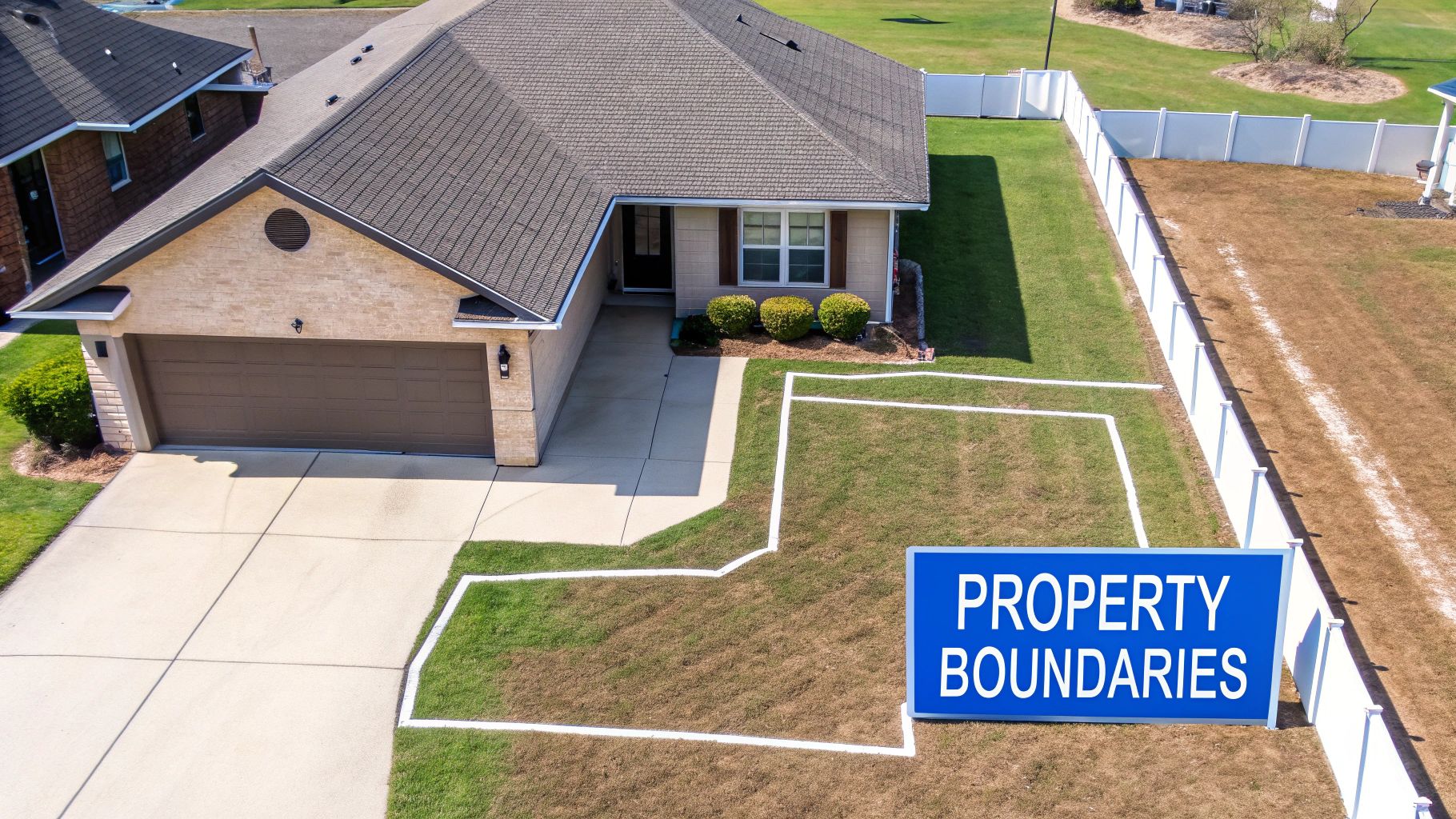
Ever look at a house for sale and wonder, "So where does my yard actually end and the neighbor's begin?" That's precisely the question a property survey answers. Think of it as the official blueprint for your land, a detailed map drawn up by a licensed professional that lays out your exact property lines.
This isn't just a simple sketch. A survey shows the lot's dimensions and pinpoints where crucial features like your house, driveway, and fences sit in relation to those boundaries. It's the one document that can save you from a world of future headaches, like discovering your brand-new shed is accidentally sitting on your neighbor’s land.
Your Land's Official Blueprint
I like to tell my clients to think of a survey as the instruction manual for their little piece of the earth. Just like a car title proves you own the vehicle and lists its specs, a survey does the same for your land, confirming exactly what you own and any special conditions tied to it. It’s an absolutely essential part of the homebuying process, delivering clarity and, most importantly, peace of mind.
To create this map, a professional land surveyor digs into historical records and then heads out to the property with specialized equipment to take painstakingly precise measurements. What you get in the end is a legally recognized document that's incredibly useful in a bunch of different scenarios.
Why It's So Much More Than Just a Map
A survey is one of the most powerful tools you have to protect your investment. While you're learning about the physical condition of a house, you might check out an expert guide to property inspection, but a survey protects you from a different set of risks.
For a homebuyer, a good survey is invaluable. It helps you:
Confirm Boundaries: You’ll know for sure where your property in White Marsh or Edgewood ends. For example, if you want to put up a fence for your dog, the survey shows you the exact line so you don't accidentally build on your neighbor's property.
Identify Red Flags: A survey uncovers things you can't see, like encroachments (a neighbor’s fence creeping onto your land) or easements (areas where others, like utility companies, have a right to access).
Secure Your Loan: Most mortgage lenders won’t even consider your application without a recent survey. They need to know the property they're financing is free of boundary conflicts.
Plan Future Projects: Dreaming of putting up a new fence or adding a deck? Your survey is your go-to guide to make sure you're building well within your legal property lines.
The demand for this kind of certainty is only growing. The land surveying market was valued at about USD 8.3 billion in 2023 and is projected to hit USD 15.1 billion by 2032. This isn't just a local trend; the need for precise land data in real estate and construction is booming everywhere.
A property survey translates the dense legal jargon on a deed into a clear, visual map of your land. It cuts through the ambiguity, giving you the confidence to enjoy and improve your home without a single worry.
Knowing the boundaries of your land is step one. But making a house truly feel like your home is where the real fun begins. While the builder I represent provides high-quality homes, I go a step further—offering my clients unique proprietary visualization tools, hands-on service, and access to visualizers that help you bring your dream space to life. We help you customize everything from flooring to cabinets, making sure your new home in Baltimore County or Harford County is a perfect reflection of you.
Why a Property Survey Is Your Best Investment
It's tempting to see a property survey as just another closing cost, but trust me, it's one of the smartest moves you can make when buying a new home. Trying to save a few bucks by skipping it is a gamble you really don't want to take.
At its core, a survey is your guarantee that you're actually getting every square foot you're paying for. It’s the ultimate peace of mind, confirming that the land described on paper is the same land you’re standing on.

Avoiding Costly "What Ifs"
Let me paint you a picture I’ve seen happen more than once. A family in White Marsh, Maryland is over the moon about building their dream patio. They hire a crew, work starts, and then—bam—the new neighbor shows up, angry. It turns out their gorgeous new patio is five feet over the property line.
A simple survey would have flagged this before a single paver was laid. It would have saved them thousands in demolition costs, legal headaches, and the stress of a feud with the neighbors. This is where a survey stops being a piece of paper and becomes a financial shield.
This need for certainty is huge. The land surveying market in the U.S. is estimated to be worth between USD 100 million and USD 150 million. That number tells you just how vital these services are for making sure property transfers go smoothly. It's a detailed process, mixing historical research with on-the-ground fieldwork to pin down every last boundary line.
Securing Your Financing
Beyond keeping the peace with your neighbors, a property survey is often non-negotiable for getting a mortgage. Lenders aren't just giving you money for a house; they're financing the entire piece of property, land and all.
A property survey is your proof to the lender that the property is a sound investment, free from hidden boundary issues that could devalue it or lead to future legal claims. Without it, your loan approval could be in jeopardy.
Most banks and mortgage companies won't even consider approving a loan without a recent survey. They need official proof that there are no encroachments or weird easements that could mess with their collateral—your new home and land.
The Foundation for Your Future Plans
Think of your survey as more than just a snapshot of today. It’s the master plan for everything you want to do in the future.
Dreaming of putting up a fence for your dog in Edgewood? Planting an elaborate garden in Baltimore County? Building a small addition? The first thing you should pull out is your survey. It helps you stay on the right side of local zoning laws and permit rules, whether you're in Harford County or elsewhere.
Knowing your exact property lines is absolutely critical for projects like excavation near neighbouring properties, where a few inches can be the difference between a smooth project and a lawsuit. Building your knowledge is a huge part of the home-buying journey, and understanding documents like this is a big step.
While the builder provides high-quality homes, I go a step further—offering my clients unique proprietary visualization tools, hands-on service, and access to visualizers that help you bring your dream space to life. We let buyers customize their homes by getting to pick their flooring, countertops, cabinets, tile, etc. It all starts with knowing the exact layout of your property. From there, we can get to the fun stuff—making that home uniquely yours.
What Kind of Property Survey Do I Need?
When you hear the term "property survey," don't assume it's a one-size-fits-all document. Think of it more like a doctor's visit—you need the right specialist for the right problem. Surveyors have a whole range of tools and techniques, and the type of survey you need really depends on what you're trying to accomplish with your property.
Choosing the right one from the get-go can save you a world of headaches and a lot of money down the road. Let’s walk through the most common types you'll run into, especially if you're buying a home in Maryland.
The Boundary Survey: Your Basic Must-Have
For most people buying a home, the Boundary Survey is the bread and butter. It does exactly what the name implies: it finds and marks the official, legally recognized boundary lines of your property. That's its whole job, and it's a critical one.
A surveyor digs into old records and then heads out to the property to physically locate and stake the corners of your lot. The final drawing you get will clearly show where your land begins and ends, along with the location of your house, driveway, and any other big structures.
Thinking of putting up a fence for the dog at your new place in White Marsh? A Boundary Survey is non-negotiable. It gives you the confidence to build right up to your property line without accidentally starting a feud with your new neighbor.
The ALTA/NSPS Land Title Survey: The Full Deep-Dive
If a Boundary Survey is like getting your car's oil changed, the ALTA/NSPS Land Title Survey is the full, bumper-to-bumper, 120-point inspection. This is the most exhaustive and detailed survey you can get, and while it's standard for commercial real estate, it's sometimes necessary for complicated residential properties, too.
This survey is a collaboration between the American Land Title Association (ALTA) and the National Society of Professional Surveyors (NSPS). It covers everything a Boundary Survey does and then piles on a ton more research, looking for anything and everything that could affect the title to the property.
You’ll get detailed information on:
Easements: Who has the right to cross or use a part of your land (think utility companies).
Encroachments: Is your neighbor's shed creeping a few inches onto your property?
Evidence of Use: That worn-down path everyone uses as a shortcut to the park might be an unrecorded easement.
Zoning Details: How the property is zoned and specific setback rules that dictate how close you can build to your lot lines.
An ALTA/NSPS survey is the gold standard for due diligence. It gives you, your lender, and the title insurance company a complete, no-stone-unturned view of the property's legal standing.
The Topographic Survey: Mapping the Lay of the Land
So far, we've talked about the flat, two-dimensional outline of a property. But what about its three-dimensional shape? That's where a Topographic Survey comes in. This type of survey is all about the land's elevation and physical features.
It creates a 3D map showing hills, valleys, slopes, and drainage patterns. It's less about where your property lines are and more about what your property is like. For example, if you're considering a property in a hilly part of Baltimore County, this survey would tell you where water is likely to run during a heavy rain, which is crucial for deciding where to place a driveway or a garden.
The Mortgage Location Survey: Just for the Bank
Last but not least is the Mortgage Location Survey. You need to be careful with this one because it isn't really for you—it's for your lender. Banks often order these as a quick, low-cost way to make sure the house is actually on the lot they're financing and not violating any major rules.
It's a simplified sketch, not a legally binding survey. It lacks the precision and legal authority of a true Boundary Survey.
Think of it as a quick check for the lender's risk department. It won't help you settle a dispute with a neighbor or give you the green light to build a new garage. It’s a tool for the bank, not a reliable document for a homeowner.
Which Property Survey Is Right for You?
Feeling a bit overwhelmed by the options? Don't worry. This quick table breaks down the essentials to help you figure out what you might need. Most of the time, the Boundary Survey is the answer for homebuyers, but it's always good to know what else is out there.
Survey Type | Best For | What It Shows | Common User |
|---|---|---|---|
Boundary Survey | Standard home purchases, building fences, pools, or additions. | Legally recognized property lines, lot corners, and locations of existing structures (house, shed, etc.). | Homebuyers & Homeowners |
ALTA/NSPS Land Title Survey | Complex residential properties, commercial real estate, and high-value land. | Everything in a boundary survey, plus easements, encroachments, zoning, and other title risks. | Lenders & Commercial Buyers |
Topographic Survey | Landscaping, drainage planning, or properties with challenging terrain. | Elevation contours, slopes, hills, valleys, and the 3D features of the land. | Homeowners & Landscapers |
Mortgage Location Survey | Lender's internal risk assessment during the mortgage approval process. | An approximate location of the house on the lot to ensure it meets basic lender requirements. | Mortgage Lenders |
Ultimately, the goal is to get the right information to protect your investment. Once you're confident about the "what" and "where" of your property lines, we can get to the fun part—making the inside of the home truly yours. From picking out the perfect floors to designing a kitchen you'll love, I have visualization tools to help bring that vision to life.
How to Read Your Property Survey Map
When your property survey first lands on your desk, it can look like an ancient, coded map. It’s a sea of symbols, strange abbreviations, and technical jargon. Don't let it intimidate you—it’s not as complicated as it looks.
Let’s break down how to read this crucial document and turn that jumble of lines into a clear story about your land. Think of it as the decoder ring for your property. Once you know what a few key symbols mean, the rest of the map will start to make perfect sense.
Getting Your Bearings First Things First
Before you dive into the nitty-gritty, you need to get oriented. Look for the foundational elements, which are usually grouped together in a corner. They set the stage for everything else.
The Legend (or Key): This is your best friend. The legend is a small box that explains what all the different symbols, lines, and abbreviations stand for. It’s the very first place you should look.
The North Arrow: Every good map needs a compass, and this is yours. The north arrow shows you how the property is oriented, which is super important for understanding things like sunlight patterns, the direction of slopes, and how your home sits on the lot.
The Scale: The scale tells you the ratio of the drawing to the real world (for example, 1 inch = 20 feet). This is how you can grasp the actual size of everything on the map, from the length of your driveway to the space you have for a backyard.
Identifying the Key Players on Your Map
Okay, now that you have your bearings, it’s time to spot the most important features. These are the lines and points that define what you actually own and what rights others might have to your land.
Your property's boundary is almost always shown as a bold, solid line. This is the official perimeter of your land. Follow this line around the map, and you’ll see the exact shape and dimensions of your lot. The corners are usually marked with a symbol indicating an iron pin or monument that a surveyor physically placed in the ground.
Another critical element to find is the Point of Beginning (P.O.B.). This is the starting point from which the surveyor began all their measurements. It acts as the anchor for the entire survey description, ensuring every line and angle is precisely located.
Easements are usually represented by dashed or dotted lines. Pay close attention to these! An easement means another party, like a utility company, has the legal right to access a specific portion of your property. It could be for underground power lines, a drainage ditch, or even a shared driveway.
For instance, you might see a dotted line running along the back of your yard in Harford County labeled "10’ Utility Easement." This means you can't build a permanent structure, like a shed or a deck, in that ten-foot strip because the utility company needs to be able to access it for maintenance.
Spotting Potential Problems and Opportunities
Finally, use the survey to look for anything that seems out of the ordinary. An encroachment happens when a neighbor's structure—like a fence, shed, or even the corner of their garage—crosses over onto your property. The survey will clearly show this overlap, giving you the hard evidence you need to address the situation.
This whole process of deciphering a technical drawing might feel familiar if you've ever looked at construction plans. If you want to get comfortable with another essential home document, you might find it helpful to learn how to read house blueprints with our homebuyer's guide.
The diagram below gives a nice overview of the different types of surveys and what they’re used for.
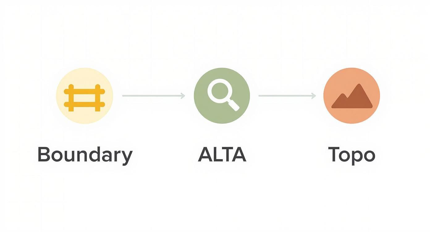
This visual helps clarify that different surveys, like a Boundary or ALTA survey, are really just tools designed for specific jobs—from simply marking fence lines to conducting a deep-dive title investigation.
Once you have a solid handle on your property's boundaries and any restrictions, you can truly start planning. My job goes beyond just providing a quality home; I’m here to offer hands-on service and proprietary visualization tools to help you bring your dream space to life. We can take that blank slate defined by the survey and customize it with the perfect flooring, cabinets, and countertops for your new home in White Marsh or Baltimore County.
The Survey Process from Start to Finish
So you know you need a property survey, but what actually happens when you order one? The whole thing can feel a bit like a black box, but it's really a straightforward process that takes you from dusty old records to a detailed, modern map of your land. Let's pull back the curtain on how it all works.
First things first, you need to find the right person for the job. You'll have to hire a licensed surveyor in Maryland—they're the only professionals legally allowed to define property boundaries. Your real estate agent or title company is usually the best place to start; they'll have a list of trusted pros they work with all the time.
The Three Main Stages of a Survey
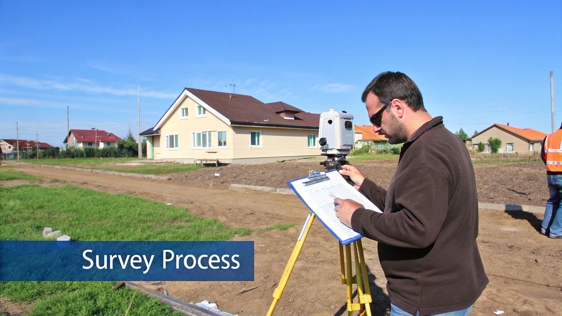
Once you’ve got a surveyor on board, their work breaks down into three key phases. I like to think of them as part detective, part explorer, and part artist.
Phase 1: The Research (The Detective Work): Long before they ever set foot on your land, the surveyor is buried in the archives. They're digging through historical deeds, checking for any past surveys, and pulling public land records for your county, whether it's Baltimore or Harford. The goal here is to build a complete picture of the property's legal history and uncover the official description that defines its shape and size.
Phase 2: The Fieldwork (The Explorer on Site): This is the part you might actually see happen. The surveyor and their crew show up at the property with some seriously high-tech gear, like GPS receivers and robotic total stations. They’ll hunt for existing property markers—often small iron pins buried at the corners—and take incredibly precise measurements. This fieldwork is all about verifying what they found in the records and physically staking out the exact lines of your property.
Phase 3: The Drafting (The Artist Creates the Map): Back in the office, all the puzzle pieces come together. The surveyor uses specialized software to combine the historical research with the hard data from the fieldwork. The result is the final survey map, which is the official, detailed drawing that shows your property's boundaries, dimensions, and any structures or easements on it.
Timelines and Costs: What to Expect
The big question everyone asks is, "How long is this going to take?" For a typical residential survey, you can usually expect it to be done in one to two weeks. Of course, that can change depending on how busy the surveyor is, how complicated the property is, and even what the weather is doing.
In Maryland, the cost for a property survey generally falls somewhere between $500 and over $1,000. The final price tag is influenced by a few things: the size and shape of your lot, the difficulty of the terrain, and how deep the surveyor has to dig into historical records.
So, who foots the bill? In the vast majority of real estate deals, the buyer is responsible for ordering and paying for the survey. Think of it as a critical piece of your due diligence. It’s how you confirm you’re actually getting the land you think you’re buying before you sign on that dotted line.
Surveying has come a long way. Back in 1620, Gunter's chain was a revolutionary tool for plotting land accurately. Fast forward to today, and the global land survey equipment market is valued at an incredible USD 8.87 billion, which just shows how essential this work is to real estate and construction.
Knowing exactly where your property lines are is fundamental, especially when you start dreaming about future projects. This information is directly tied to other legal hoops you might need to jump through, like getting a building permit. To connect the dots, check out our guide on what a building permit is for homeowners.
Bringing Your Perfect Home Vision to Life
Once you've nailed down the property lines, the real fun begins. A survey gives you the canvas, but it's what you do inside those lines that turns a structure into a home. The technical stuff is out of the way; now it's time to create your masterpiece.
A well-built house is the foundation, but my job is to help you perfect every last detail inside. I give my clients exclusive access to some incredible visualization tools that let us bring your design ideas to life, long before a single can of paint is opened.
Designing Your Dream Space
Imagine being able to play with different design elements in your home without any of the commitment. That's exactly what our visualizers let you do. You can digitally swap out materials, experiment with colors, and see how everything looks together in a virtual model of your house.
Flooring: Want to see how that dark walnut hardwood looks next to the light and airy paint you chose? Let's check.
Countertops: Torn between a classic granite and a modern quartz? We can compare them in your kitchen in seconds.
Cabinets: Test drive different shaker-style doors or sleek, modern finishes to find the perfect match.
Tile: From the backsplash to the master bath, we can design the layout and color scheme together.
This whole process is designed to take the guesswork—and the stress—out of making those big decisions. You get to move forward with total confidence, knowing the home you walk into on day one is the exact home you've been dreaming of. No surprises, no regrets.
While the builder I represent provides high-quality homes, I go a step further—offering my clients unique proprietary visualization tools, hands-on service, and access to visualizers that help you bring your dream space to life.
This partnership is everything. Juggling all the different pros, from surveyors to tilers to electricians, is a massive undertaking. To get a better sense of who leads that team, check out our guide on what a general contractor is and why you need one.
If you’re looking for a new home in premier Maryland communities like White Marsh, Edgewood, Baltimore County, or Harford County, I’m here to be your partner in that process. Let's connect and start designing the perfect space for you.
Got Questions? We've Got Answers
If you're buying a home, it's totally normal for a million questions to bubble up, especially with something as technical as a property survey. Let's break down a few of the most common ones I hear from clients.
Can I Just Use the Seller's Old Survey?
This is a big one, and I get why people ask—it seems like a simple way to save a few bucks. But honestly, the answer is almost always a hard no. Your lender and the title company want to see what the property looks like today, not five or ten years ago.
An old survey is a snapshot in time. It won’t show that new fence the neighbor built last summer that's two feet over the line, or the deck the sellers added without a permit. A fresh survey gives everyone involved—especially you—a crystal-clear, current picture of the property, protecting you from inheriting someone else's headache.
What Happens If the Survey Finds a Problem?
Okay, take a deep breath. Finding an issue, like your potential neighbor's shed sitting on what's supposed to be your yard, can feel like a huge deal. But this is exactly why you get the survey in the first place—to catch these things before you sign on the dotted line. It’s a good thing, not a deal-breaker.
This is where your real estate agent and attorney step in to negotiate a solution. Maybe the seller gets the neighbor to move the shed, or perhaps a formal easement is drawn up to make it official. The point is, you discover the problem while you still have the power to fix it, before it becomes your problem.
Will I Need Another Survey Down the Road?
So you've closed on the house and have your survey tucked away. Are you done for good? Probably not. You'll likely want a new survey before you kick off any major home improvement projects.
Think of your survey as the official blueprint for your property. Any time you plan to change that blueprint, you need to make sure your plans are based on the most current information available.
It's a smart move to get an updated survey if you’re planning to:
Put up a new fence (the classic reason!)
Add on to your house
Install a swimming pool or a large patio
An updated survey ensures your new project in White Marsh or Harford County meets all the local setback rules and is built squarely on your own turf, saving you from any potential disputes with your neighbors later on.
While a builder provides a high-quality home, my team and I go a step further. At Customize Your Home, we offer clients unique visualization tools and hands-on service to bring your dream space to life. We let buyers customize their homes by getting to pick their flooring, countertops, cabinets, tile, etc., ensuring the home you buy is perfectly you.
Explore your options and start designing your ideal home with us today at https://www.customizeyourhome.com.
Comments